 |
| Flying Pony. (J. Adam Huggins for The New York Times) |
Thursday, September 11, 2014
Both Edgy and Homey
Michael Kaminer conveys the changing face of the Gerrard East strip for the the New York Times in "For Toronto’s Little India, a New Crowd".
Tuesday, March 18, 2014
"For" vs "By": Affordable Housing Back in the Day
The Toronto Star has been running a cool series to find "hidden experts" as part of their year-long Big Ideas project on how to make Toronto better.
On March 8th, Craven Road was mentioned in an intriguing article by Laura Kane, 'Hidden experts' have Big Ideas (and some small ones) for affordable housing:
When Nicole Stewart imagines the future of Toronto, she likes to think small — really small.
The policy development officer in the City of Toronto’s Affordable Housing Office wants to see “tiny homes” built in backyards and laneways across the city. The teensy-tiny abodes could be between 100 and 800 square feet, made from recycled materials and energy-efficient....
“What I’m suggesting isn’t any sort of shanty town or RV home in the city. I’m talking about really well-made, well-designed homes,” she said. The phenomenon has exploded across the U.S., Europe and in some Canadian cities like Vancouver. But Toronto’s building code still contains some provisions that prevent landowners from building tiny homes.
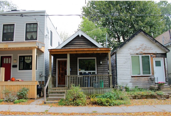
The city does have a “Tiny Town,” on Craven Rd., near Gerrard St. E. and Coxwell Ave., the largest concentration of detached houses under 500 square feet in Toronto. The homes were built for manual labourers at the turn of the 20th century.
Because as important as social housing is, the idea that the houses on Craven Road were built "for" rather than "by" the people who lived in them is simply ahistorical.
Walk down the street and you'll see the evidence. There is no central planning or design:
 |
| from Spacing.ca |
 |
| from the MASH |
 |
| from Walking Woman |
 |
| from Walking Woman |
These houses were built according to the individual vision of whoever acquired each small lot. And even those lots are irregular sizes, since the land was sold by the foot, like cloth off a bolt.
That's why manual labourers bought and built on Craven Road:
That's why manual labourers bought and built on Craven Road:
Thursday, February 20, 2014
Weird Street
"Is Craven Road the weirdest street in Toronto?" asks a new post on blogTO.
Why, thanks for asking. Yes. Yes it is.
And the weirdest thing of all is the cloud of urban legends that shrouds its origins. Chris Bateman (who wrote a wonderful article three weeks ago about the history of his own street, Highfield Road) repeats the theory first shared by Amber Daugherty in Spacing that
But it's not true.
Neither Craven Road (formerly Erie Terrace) nor Ashdale Avenue appear on a map of the area from 1892. Then they both make their debut, side by side, in the 1910 Goad's Atlas of Toronto, the year after the City of Toronto annexed their neighbourhood (formerly called Midway). See this post for both maps.
In Pigs, Flowers and Bricks: A History of Leslieville to 1920, Joanne Doucette gives a different account of Craven's origins:
The truth is that in 1916, after much political wrangling with the residents of both streets, the City of Toronto did indeed widen Erie Terrace, from as little as 18 feet in places, to the city's legal minimum of 33 feet. Far from being out of pocket, Ashdale's homeowners did not pay for the widening of a street they did not front on, and they received fair market value for the sale of between nine and fourteen lot-depth feet of their (to this day, quite considerably deep) backyards.
The city paid less than half of the $44,500 to buy the backyard land and grade the street. The lion's share, $25,000, was charged to the owners of property on Erie Terrace, at a rate of $4.85 per foot of frontage. As the Toronto Star remarked at the time, this was "a heavy tax on land worth only $20 per foot."
And the fence?
The idea of a mini, wooden Berlin Wall to keep the "rowdy poor" of Erie Terrace out of the backyards of their more affluent Ashdale neighbours is a colourful story. I happily told it for years.
But as it turns out, it was actually the other way around. A 1913 Toronto Star article reports:
The blogTO post also highlights a brilliant new documentary short about Craven Road from director Kire Paputts:
Craven Rd (Director's Cut) from Made By Other People.
There are five more finished episodes in this series serving up piquant slices of life on Gerrard Street East, produced by Paputts and veteran producer Colin Brunton, who mentions in the comments that
Why, thanks for asking. Yes. Yes it is.
And the weirdest thing of all is the cloud of urban legends that shrouds its origins. Chris Bateman (who wrote a wonderful article three weeks ago about the history of his own street, Highfield Road) repeats the theory first shared by Amber Daugherty in Spacing that
before Craven Road, the Ashdale homes had huge backyards that were more than 42 metres long, prompting owners to subdivide their lots. After a dispute over who owned the property surrounding the homes, the city bought the land in question, put up the fence, and laid down the road.It's a nifty folktale.
But it's not true.
Neither Craven Road (formerly Erie Terrace) nor Ashdale Avenue appear on a map of the area from 1892. Then they both make their debut, side by side, in the 1910 Goad's Atlas of Toronto, the year after the City of Toronto annexed their neighbourhood (formerly called Midway). See this post for both maps.
In Pigs, Flowers and Bricks: A History of Leslieville to 1920, Joanne Doucette gives a different account of Craven's origins:
This street was developed as a 'shacktown', outside of Toronto, in the 1890s... Ashdale Avenue was not subdivided until later. No houses were built until later when its large lots were sold to more affluent buyers. This is why Craven Road only has houses on the east side. Ashdale Avenue's bigger homes were built with their backs turned on disreputable Erie Terrace. The rowdy poor of Erie Terrace were often accused of trespassing.
When the City of Toronto widened Erie Terrace, Ashdale's home owners had nothing to gain. They lost some of their property and taxes went up to pay for the wider street. A deal was made. The City of Toronto put up a tall wooden fence to keep the poor out of Ashdale yards.Better, but still not quite the full story.
The truth is that in 1916, after much political wrangling with the residents of both streets, the City of Toronto did indeed widen Erie Terrace, from as little as 18 feet in places, to the city's legal minimum of 33 feet. Far from being out of pocket, Ashdale's homeowners did not pay for the widening of a street they did not front on, and they received fair market value for the sale of between nine and fourteen lot-depth feet of their (to this day, quite considerably deep) backyards.
The city paid less than half of the $44,500 to buy the backyard land and grade the street. The lion's share, $25,000, was charged to the owners of property on Erie Terrace, at a rate of $4.85 per foot of frontage. As the Toronto Star remarked at the time, this was "a heavy tax on land worth only $20 per foot."
And the fence?
The idea of a mini, wooden Berlin Wall to keep the "rowdy poor" of Erie Terrace out of the backyards of their more affluent Ashdale neighbours is a colourful story. I happily told it for years.
But as it turns out, it was actually the other way around. A 1913 Toronto Star article reports:
Residents on Ashdale avenue are asking for a right-of-way on to Erie terrace, but the residents of Erie terrace have strong objections to their neighbors deriving benefit from the widening of their street, an improvement they have to pay for. In the widening of Erie terrace there was a foot reserved strip left between the rear of the Ashdale avenue lots and the new roadway on Erie terrace. This strip was reserved to prevent the property owners on Ashdale avenue building on the street line on Erie terrace.Sure enough, in 1916 the Star immortalizes the construction of the street's iconic fence while reporting on a lawsuit brought against the city by one Ashdale owner who had painted himself into a corner:
Mr. H.M. East owned a lot fronting on Ashdale avenue about 134 feet deep. The city expropriated the rear 14 feet or thereabouts. Subsequently Mr. East sold the front 90 feet, leaving himself with some inaccessible rear land, because in widening Erie terrace the city is erecting a high fence to prevent the residents of Ashdale avenue obtaining access thereto. Consequently Mr. East can only obtain access to his property from Ashdale avenue over the land sold by him.For all the gory details on the origins of Craven Road see last year's posts Origin Stories and On the Fence, as well as the Toronto Archives' 1916 documentation in Craven Road in Archive Photos.
The blogTO post also highlights a brilliant new documentary short about Craven Road from director Kire Paputts:
Craven Rd (Director's Cut) from Made By Other People.
There are five more finished episodes in this series serving up piquant slices of life on Gerrard Street East, produced by Paputts and veteran producer Colin Brunton, who mentions in the comments that
We're currently shooting a few more episodes of this little series: its all about the Coxwell/Gerrard area. We're looking for old photos and Super-8 footage; stories, gossip, rumours and tall tales about the stretch of Gerrard Street that goes from Coxwell to Pape in Toronto, from Little India to Gerrard Square and the Maple Leaf Tavern. We want to get it down before it turns into condos and coffee shops. There's a Facebook page people can join if they want: https://www.facebook.com/groups/702749939738437/
Monday, December 30, 2013
Build-It-Yourself
In Pigs, flowers and bricks : A History of Leslieville to 1920, Joanne Doucette recounts that "Working class families often built their own homes. Sometimes they lived in a tent or in the basement of their house while working on building the rest of the house over their heads."
So you can imagine the allure of a mail-order home that came flat-packed like an Ikea bookcase, and promised that you didn't even need a saw to assemble it. A "knocked-down" house kit included everything from the pre-cut foundation timbers to the shingles, along with instructions for the owner-builder to put it together themselves.
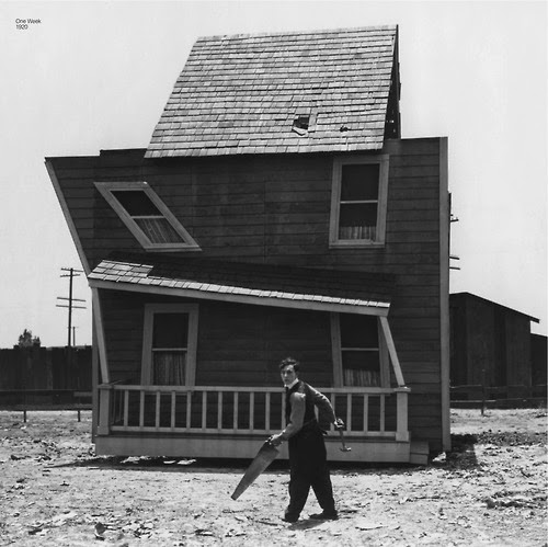
First introduced around the turn of the last century, this revolutionary new housing solution became so popular that Buster Keaton featured it in his first solo film, the 1920 silent short One Week.
Aladdin Readi-Cut Homes – named for the fable in which a genie builds his master a palace overnight – used the tag line "Built in a Day". They claimed that "Skilled labor is absolutely unnecessary in any part of the erection and completing of an Aladdin house – because we supply the skilled labor in our mill, preparing the entire house for you to fit together in a few days."
So you can imagine the allure of a mail-order home that came flat-packed like an Ikea bookcase, and promised that you didn't even need a saw to assemble it. A "knocked-down" house kit included everything from the pre-cut foundation timbers to the shingles, along with instructions for the owner-builder to put it together themselves.

Aladdin Readi-Cut Homes – named for the fable in which a genie builds his master a palace overnight – used the tag line "Built in a Day". They claimed that "Skilled labor is absolutely unnecessary in any part of the erection and completing of an Aladdin house – because we supply the skilled labor in our mill, preparing the entire house for you to fit together in a few days."
Saturday, December 28, 2013
Once Upon a Time in Shacktown
As the 2013 ice storm reminds Torontonians how lucky we (usually) are to enjoy mod cons like electricity, here comes another way for the more fortunate to experience life without them. The five-star Emoya Luxury Hotel and Spa points out that "Millions of people are living in informal settlements across South Africa... Now you can experience staying in a Shanty..."
Well, maybe not exactly. Located "within the safe environment of a private game reserve," this is "the only Shanty Town in the world equipped with under-floor heating and wireless internet access."
We may jeer, but maybe, in some twisted way, this is part of the mental gymnastics the average Westerner needs to do to understand our relative wealth in its global context.
Hans Rosling has created some fabulous "stats performance" videos to help us. This one from "Don't Panic: The Truth About Population" lays out the daily incomes of the seven billion people alive today along a "yardstick of wealth":
Sunday, October 20, 2013
Map Art
Speaking of cartography (we were – it was just a while ago), the rather awesome website maps.stamen.com lets you make your own beautiful aerial imagery using OpenStreetMap data. Here's an interactive view of the Craven Road area – click to zoom and drag to navigate!
And here are two map images, one in Stamen's "Watercolor" style, and the second in "Toner":
And here are two map images, one in Stamen's "Watercolor" style, and the second in "Toner":
Sunday, September 15, 2013
A Century-Composite Map
Following yesterday's post of maps from the early days of the Craven Road area, here's a fun bonus:
 |
| (Click above for larger image) Combined 2009 and 1913 maps |
Saturday, September 14, 2013
Early Maps of the Area
The earliest maps of the Craven Road area offer a fascinating journey. They don't always necessarily agree with each other, but each one gives some quirky little spark of discovery that can fire your imagination.
Let's start in one of the earliest years the neighbourhood appears on a map, at least in any recognizable detail. This image, courtesy of the City of Toronto Archives via Nathan Ng's fabulous website Historical Maps of Toronto, is from an 1851 map of the Township of York.
The road across the top will become Danforth Avenue, and the one marked "Kingston Road" will become Queen Street East up to the point where it veers off diagonally at the point marked "Tavern" and "Steam SM" (the location of a steam-powered sawmill – see page 6 of The Beach in Pictures). The map shows a few buildings, the numbers dividing the concession into 100-acre lots, some marshy area around Ashbridges Bay, and... not much else:
McGill University's Canadian County Atlas Digital Project includes a map from 1878 which shows Greenwood Avenue on the left-most side, with various "Heirs of Jesse Ashbridge" listed as owners of strips of land moving eastward till a "J. Platt" appears, then two blank lots (which are probably on either side of what will eventually become Coxwell Avenue), followed by a "Sam Hill". The road on the right-hand side is Woodbine Avenue:
Let's start in one of the earliest years the neighbourhood appears on a map, at least in any recognizable detail. This image, courtesy of the City of Toronto Archives via Nathan Ng's fabulous website Historical Maps of Toronto, is from an 1851 map of the Township of York.
The road across the top will become Danforth Avenue, and the one marked "Kingston Road" will become Queen Street East up to the point where it veers off diagonally at the point marked "Tavern" and "Steam SM" (the location of a steam-powered sawmill – see page 6 of The Beach in Pictures). The map shows a few buildings, the numbers dividing the concession into 100-acre lots, some marshy area around Ashbridges Bay, and... not much else:
 |
| (Click here to access the full map) 1851 Map of the Township of York in the County of York Upper Canada, by J.O. Browne |
Saturday, August 24, 2013
Craven Road in Archive Photos
The five earliest photos of Craven Road in the City of Toronto Archives were taken on June 16, 1916, after the city decided to buy up a slice of Ashdale Avenue's backyards in order to widen the narrow, one-sided laneway then called Erie Terrace.
 |
| Erie Terrace, looking south, 1916 (Toronto Archives, Fonds 1231, Item 2243) |
Ironically, these images show Erie Terrace's dirt road and wood-plank sidewalk, but reveal very little of its houses. The photos look south and a little west, focusing on the Ashdale side of the street, since they were taken to record the backyard property being expropriated to widen the street.
Friday, August 23, 2013
On the Fence
 |
| 1915 map of Toronto's annexed districts with dates (detail – click here for full map) |
The district of Midway became part of the City of Toronto in 1909. Not long afterward, narrow, unpaved Erie Terrace (as Craven Road was then called) became a headache for city politicians:
Friday, August 9, 2013
The Media Discover "Tiny Town"
"In the east end of Toronto, between Coxwell and Greenwood Avenues, there’s a place called 'Tiny Town.' The neighbourhood name might not show up on a map, but if you travel up and down Craven Road you’ll realize that the area is truly the epitome of modest living.
On Craven, you’ll find the largest collection of single houses under 500 square feet in the city. You’ll also find the longest wooden (and municipally maintained) fence in the city."Spacing's February 13, 2013 article "Tiny House Society of Craven Rd.", quoted above, is just one of several features on the street in the past few years.
Thursday, August 8, 2013
Fun with Math
Craven Road (formerly Erie Terrace) has been in the news a few times over the years.
The earliest mention I could find, thanks to the Toronto Star's addictive "Pages from the Past" archive, was in a real estate ad from 1906, offering land for as little as $2 per foot of street frontage:
A century and a bit later, on 22 February 2013, the same paper profiled a "House of the Week" at the bottom of the street, a brand-new, three-bedroom magazine-bait beauty selling for $889,000.
How do the prices compare?
The earliest mention I could find, thanks to the Toronto Star's addictive "Pages from the Past" archive, was in a real estate ad from 1906, offering land for as little as $2 per foot of street frontage:
 |
| (Toronto Star, May 5, 1906, p27) |
"ERIE TERRACE, Adjoining Reid Ave., $2.00 to $5.00 per foot. $5.00 cash, $5.00 per month." (Interesting to note that prices are half of those for plots on Reid Avenue (
now Rhodes Avenue), only one block to the east.)A century and a bit later, on 22 February 2013, the same paper profiled a "House of the Week" at the bottom of the street, a brand-new, three-bedroom magazine-bait beauty selling for $889,000.
How do the prices compare?
Wednesday, August 7, 2013
Origin Stories
In February 2013, the magazine Spacing published an admiring article titled "Tiny House Society of Craven Rd.", which included a theory on the origins of this quirky street:
And the idea that the narrow laneway was carved out of the backyards of Ashdale Avenue may be derived from the fact that when the City widened Erie Terrace in 1916, they did so by buying a chunk of the Ashdale residents' backyards.
But Erie Terrace was always its own road. The most detailed account of its history comes from the 2011 book Pigs, Flowers and Bricks: A History of Leslieville to 1920, an epic labour of love by Joanne Doucette:
Craven Road was once known as Erie Terrace, but before that, these lots that now house tiny buildings were attached to the back of properties on Ashdale Avenue — properties that used to extend back from the road over 140 feet. [Jack Ridout, a real estate agent whose family grew up on the road] says those who lived in the houses gave people materials to build places at the back of their lots. When there was a dispute over whose land belonged to whom around 1910, the City stepped in, expropriated the land, and created a tiny road between the houses on Ashdale and the rear lots.The mention of building materials probably springs from this 1907 ad in the Toronto Star:
 |
| "$10 A FOOT – Erie Terrace, 100 feet north of Gerrard street cars, no money down, lumber supplied to build. Davis, 75 Adelaide east." |
And the idea that the narrow laneway was carved out of the backyards of Ashdale Avenue may be derived from the fact that when the City widened Erie Terrace in 1916, they did so by buying a chunk of the Ashdale residents' backyards.
But Erie Terrace was always its own road. The most detailed account of its history comes from the 2011 book Pigs, Flowers and Bricks: A History of Leslieville to 1920, an epic labour of love by Joanne Doucette:
Subscribe to:
Posts (Atom)